
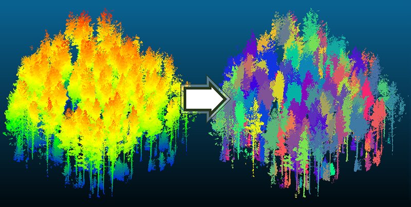
This figure shows the input and output of the tree segmentation algorithm. The input data (left) is colored by height. The results of the algorithm (right) use color to segment each tree from the point cloud. Credit: Purdue University photo/Joshua Carpenter
How lightning travels from the sky to the ground has inspired the concept of a new algorithmic approach to digitally separate individual trees from their stands in automatic forest mapping.
“When lightning moves from the sky to the ground, it takes the path of least resistance through the atmosphere,” said Joshua Carpenter, Ph.D. student at the Purdue Lyles School of Civil Engineering. This led him to the same opinion about the digital format the forest data, or point cloud.
“If I could somehow see all the points in that cloud of points as the path of least resistance, that would tell me something about where the tree is,” Carpenter said. The concept also works in terms of plant biology.
“Every leaf of a tree needs to be supplied with nutrients, and nutrients come from the ground. So we find the shortest path for the tree’s nutrients from the crown to the ground.”
Carpenter and four Purdue co-authors published details of their mapping methods recently in the journal Remote sensing. This approach means the difference between mapping a few trees and mapping hundreds of acres at once, quickly and with high accuracy. It could also lead to the creation of digital twins of forests, which could improve management planning in the face of climate change, disease outbreaks and population growth.
“We have developed a new custom tree segmentation algorithm that can be used to conduct tree inventories over large areas,” said paper co-author Jinha Jung, an associate professor in the Department of Civil Engineering. Carpenter is a member of Jung’s Geospatial Data Science Laboratory, which specializes in mapping and measurement.
“Another contribution of this work is how to evaluate the performance of a segmentation algorithm using data collected from the ground,” Jung said.
The algorithm proved to be more accurate on most metrics, often by a large margin compared to the state of the art. The validation involves directly marking and measuring individual trees in the field to correlate with LiDAR data collected at ground level and from the air at different times of the year to capture trees with and without leaves.
The team is still working out the challenges posed by their three data collection methods: photogrammetry (creating 3D images from 2D photographs) and two types of LiDAR (airborne and ground-based).
The data in the point cloud have the same structure, but the data from each method contains different anomalies. It is possible to capture the upper parts of the tree crown quite well, but miss the trunk elements, and vice versa. Sometimes features in landscape mode also block data collection.
“The goal is to use all the different point clouds that are available to create a flexible algorithm,” Carpenter explained. “But to come up with a method of working with each of the specific anomalies is difficult.”
Working in the 400-acre Martell Forest about 8 miles east of campus, the Purdue team continues to expand the scope of its technology.
“How can we go from a few hundred hectares to a few thousand or a few hundred thousand, and then to every tree on the planet? That’s the future,” said paper co-author Songlin Fei, professor and dean of the Department of Remote Sensing in Forestry and Natural Resources. “The question is how to scale it up.”
The inventory requires tedious field work to sample 5% or 10% of the area. “One hundred percent inventory was never an option. This article demonstrates the technologies that make it possible to take a census of every tree. We’re talking about a huge jump,” Fay said.
The Remote sensing The paper focuses on forest mapping, but more algorithms will be needed to carry out a full inventory.
“We can make diameter measurements with this data. But what about other key inventory characteristics like straightness, wood grade, or species identification? Those haven’t been done yet,” Fay said.
Now these technologies make it possible to create a digital double of an entire forest to see the possible effects of ice or strong winds.
“When you do a forest management plan, you can’t just harvest trees and see what it looks like,” Fay noted. “But in the digital world, you can cut down any tree you want and put it back. It allows you to do simulations and do better management planning.”
In recent decades, geospatial data significantly increased agricultural production. Purdue researchers aim to do the same for forestry, a source of important raw materials for construction and fuel. Catastrophic wildfires and invasive species that have destroyed large stands of American chestnut and ash are now focusing attention on the importance of forests.
“We’ve successfully applied all of these technologies to agriculture,” Carpenter said. “But other domains now demand our attention.”
Joshua Carpenter and others. An Unsupervised Canopy-to-Root Tree Segmentation Algorithm (UCRP) for Automatic Forest Mapping, Remote sensing (2022). DOI: 10.3390/rs14174274
Provided
Purdue University
Citation: Research team presents advanced technology for automatic forest mapping (2022, October 4) Retrieved October 4, 2022, from https://phys.org/news/2022-10-team-advance-automatic-forest-technology.html
This document is subject to copyright. Except in good faith for the purpose of private study or research, no part may be reproduced without written permission. The content is provided for informational purposes only.


")


